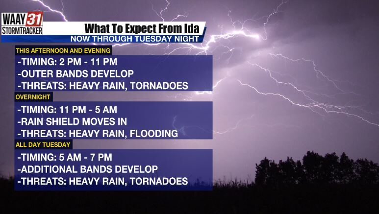


Tropical Storm Ida continues to move further inland this morning, with the center of the storm now located in southwestern Mississippi. Many Flash Flood Warnings are in effect for Louisiana, southern Mississippi, and coastal Alabama. Several Tornado Warnings have also been issued throughout the morning as well. Here at home, we will stay quiet through the morning hours. However, with peak daytime heating and Ida moving closer to North Alabama today, expect impacts to begin in our area this afternoon that last through Tuesday evening.
There will be a 36 hour window where heavy rain, flooding, and brief spin up tornadoes are all on the table. There's a lot of components to this forecast so here's a breakdown of what we can expect chronologically through Tuesday evening.

The worst of Ida moves out Tuesday evening. While a few lingering showers will be possible until Wednesday morning, the flooding and severe weather threat end around sunset Tuesday. Our main concerns continue to be heavy rain and flash flooding. A Flash Flood WATCH is in effect for all of our counties from 1 PM today to 1 AM Wednesday.

Rainfall amounts of 3 to 4 inches are likely for the entire area over the next 36 hours. Locally higher amounts will be possible for areas closer to the center of Ida (mainly the Shoals) and for areas that see heavier rain from thunderstorms in outer bands that develop.

Within any of those bands that develop, brief spin up tornadoes will also be possible.

Once Ida moves out, the rest of the week and the holiday weekend look spectacular as a drier and less humid airmass moves in. Highs stay in the mid 80s with plenty of sunshine and overnight lows possibly in the upper 50s in outlying areas.