

Nothing more than isolated light rain showers are expected this evening through tonight. As the rain clears out, areas of dense fog may redevelop. Overnight lows will be in the mid 50s. Most of us will get a break from the wet weather tomorrow. Nothing more than a few showers are expected near the I-59 corridor. Highs will be in the low 60s.
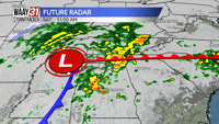
We're not in the clear just yet though. Another wave of widespread rain and storms is expected from midnight Friday night through 3 pm Saturday. Isolated severe wind gusts will be possible with these storms mainly around Sand Mountain. An additional 1-2" of rain can be expected and may lead to more flood issues.
A cold front will move through Saturday night and put an end to the wet weather for a while. Highs will go from the low 60s Saturday to the mid 40s on Sunday. Highs will stick around the 50s and 60s next week.
TONIGHT: Isolated showers. Chance of rain: 30%. Lows in the mid 50. Wind: SW/N 5-10 MPH.
FRIDAY: Mostly cloudy. Likely dry. Chance of rain: 20%. Highs in the low 60s. Wind: N 3-6 MPH.
Ìý