
After a reprieve from pop up storms yesterday, the active weather returns today and Friday. We are all dry this morning with temperatures in the low 60s. The frontal boundary that stalled near Birmingham yesterday will lift back to the north as a warm front. Some pop up showers and storms will be possible late this afternoon as a result. The higher rain chances, however, will hold off until after sunset.
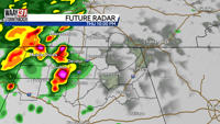
We are tracking two rounds of storms over the next 36 hours. The first round arrives this evening and lasts through the overnight hours. Storms are expected to weaken past midnight, but any stronger storms will be capable of damaging wind gusts and heavy rain. The Friday morning commute does not look quite as messy, but lingering showers will continue. As the cold front itself moves into North Alabama after sunrise Friday, we will turn into "nowcasting" mode to determine if any fuel is left in the atmosphere following the first round of storms. Should we see that fuel materialize, there will be a narrow window for additional strong storms to develop over northeast Alabama between 10 AM and 1 PM Friday. Damaging winds will once again be the main concern. The severe weather threat ends with the passage of the cold front tomorrow afternoon, but lingering showers stick around into the evening.
Mother's Day weekend looks spectacular! Outside of a few sprinkles early Saturday morning, we will be treated to sunshine and highs in the mid 70s! Mother's Day itself features more of the same with warmer temperatures in the 80s. Our first heat wave of the season is on the way! Highs will be in the upper 80s to low 90s all of next week with sunshine and little in the way of rain chances.