
** Freeze Warning in effect 1 AM through 9 AM Tuesday**
Today is the First Day of Spring but we are sure not feeling it with well below average temperatures.Â
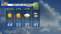
The good news of the day is that we will have plenty of unobstructed sunshine that will gradually warm our high for the day to 53 degrees with the slightest hint of the breeze.
Another Freeze Warning is in effect Monday night into Tuesday morning at 9 AM ahead of temperatures right at or slightly below the freezing mark. The good news is that this will be our last Freeze Warning for some time!

Bring your umbrella with you as you head out the door Wednesday morning, scattered rain chances will be in the area. While it will not be an all out wash-out, periods of heavy rain through the later afternoon are possible.
Later this week, we really start to feel like spring with Wednesday's high in the upper 60s, Thursday's high right at 80, and Friday's high in the mid-70s.
We're tracking storms all day Friday, so be sure check-in multiple times on Wednesday and Thursday to get the most up-to-date timing on when the storms will be in your neighborhood.
MONDAY: Mostly sunny. Highs in the low 50s. Wind: NE 5-10 MPH.
TONIGHT: Increasing clouds. Lows in the low 30s. Wind: SE 1-5 MPH.