
A very warm and stormy end to 2021 for north Alabama.
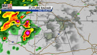
A few hit and miss showers will be possible tonight through tomorrow morning but nothing heavy or widespread for your Tuesday morning commute. We'll see a bit higher coverage of showers and thunderstorms by Tuesday evening into early Wednesday morning. It is possible that an isolated storm or two could become strong to marginally severe. Keep in mind this is not the main severe threat for Wednesday.Â
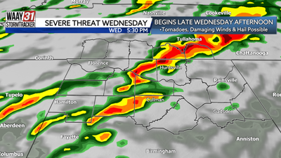
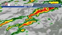
A much higher severe weather threat is back in the forecast for North Alabama beginning Wednesday afternoon. The entire region has been placed in a Level 2 risk for severe storms. The severe weather risk lingers overnight into early Thursday morning.
Damaging winds and heavy rain are the main concerns. A lower risk for brief spin up tornadoes is also there. The severe weather risk ends before sunrise Thursday but the active weather pattern continues.
Off and on showers linger Thursday and for New Year's Eve Friday. By Saturday (New Year's Day), a more significant severe weather threat is on the table for much of the mid-South including our area. Beyond that, we can't get into the specifics just yet. However, we will need to watch this system very closely in the days to come. Outside of the severe weather threats, much of the area will see 3 to 4 inches of rain in the next seven days which may lead to flooding concerns to start off the new year. Behind Saturday's system, temperatures crash to more seasonable levels by early next week.